
Today we ride from the foothills of the highest peaks of the French Alps to the lowlands of Bresse. It’s a big change of scenery for the peloton!
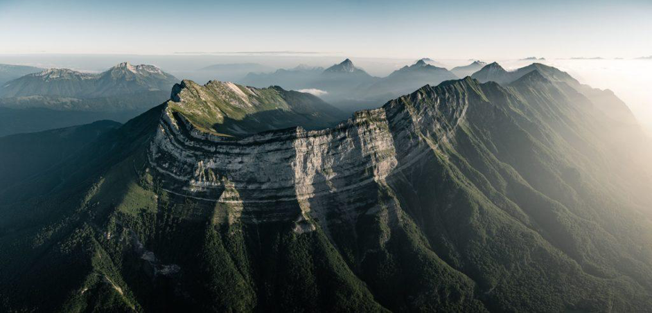
The major part of today’s route follows deep valleys carved by ancient Alpine glaciers. These valleys are now occupied by the Isère River and its tributaries. On both sides of the valleys, you can observe deformed strata of limestones and marls looking like squeezed layer cakes. Unlike most rocks that we saw during the last three stages, these layers are barely transformed by heat and pressure. They have only been gently folded. Indeed, we are now leaving the core of the Alps, where rocks were buried and significantly modified by the high stress of the collision between the Eurasian and African Plates.
A tablecloth?
The gently-folded rocks we see now can be found all along the outer rim of the Alps. They correspond to marine layers pushed away from the collision zone, on the Eurasian Plate. In geology, we call them “nappes”. It’s the French name for tablecloth. You can picture them as a blanket pushed slowly onto the Eurasian basement rocks.
A drastic change
The folded marine layers date back to the Jurassic and Cretaceous periods, 200 to 66 million years ago. If you have seen Jurassic Park, you probably know that these were dinosaur times. But did you know that the word “Jurassic” comes from the Jura Mountains? We reach its southernmost tip today after crossing the Rhône River?
These marine rocks are the remnants of shallow seas and deeper basins that once extended along the southern Eurasian margin. They disappeared during the collision between the Eurasian and African Plate 60 to 50 million year.

Dinosaurs have left several impressive trackways in the Jura Mountains. Some of them apparently enjoyed a change of scenery as well when they were walking along the sea. They left their gigantic footprints on coastal mudflats forever! (More on that tomorrow!)
You won’t find many land dinosaur fossils in these layers. However there are many marine reptiles such as giants ichthyosaurs and plesiosaurs. They swam around in this lovely tropical sea. There are also many ammonites. Remember these iconic fossil mollusks with spiral shells that disappeared at the end of the Cretaceous? (Also see stage 7.)
A pinch of salt
We finally leave the Jura Mountains and reach the flat plains of the Bresse Basin. Here, the interesting rocks lie right below our feet. Sedimentary cores tell us that since the dry-out of the Cretaceous shallow marine seas, the Bresse Basin has been mainly occupied by wide salty lakes. For part of the Oligocene, 34 to 23 million years ago, these lakes connected to other brackish lakes in the Rhine Valley further north and in Provence further south. Together they formed a long belt of water connecting the Mediterranean Sea to the North Sea.

These ancient lakes are famous for their numerous fossil insects, papyraceous limestones, and thick beds of salt and gypsum. In the Bresse area, up to 1.2 km of salt deposits at the center of the basin are invisible today. They are below younger sediment. Our peloton won’t notice them while they race towards the finish line. They will only see the salt caking their jersey due to the heat of summer and notice the dramatic change of scenery.
