
It is not often that a normally very quiet street, away from the hustle and bustle of the city, is the center of attention. Unless the Spring Classics kick off and the run-in to the Paterberg, the start of the finale in the E3 Saxo Classic and the final climb before the finish in the Tour of Flanders, went landsliding. Time to look at the geology of the Tour of Flanders, and the E3.
Geo-Sports.org links geology to cycling through daily blogs during the Tour de France (Femmes) and the five monuments of our sport. And there is no place else where racing and geology are so intertwined this month as in the Middelloopstraat in Kluisbergen.
Let it rain
The Low Countries experienced record rainfall in recent months. In the province of West Flanders, there were many floods but also in other provinces such as East Flanders where the Paterberg is located, the abundant rainwater caused problems. In the Middelloopstraat, the final approach to the Paterberg, this led to a landslide.

The ground there literally collapsed next to the road. To explain why this happened here, putting the passage of the E3 and the Ronde over this iconic climb in danger, we have to dig into the geological history.
The Flemish Ardennes are part of the plateau of central Belgium. You may remember from geography lessons: level horizons, incised valleys. Unlike the more easterly regions of central Belgium, the valleys in the Flemish Ardennes, are more deeply incised and closer together. So, you get steeper slopes, which is why cycling races are so often found here. However, those steep slopes come with greater risks.

The geology of the land slide
Besides its culinary specialties such as geutelingen and mattentaarten, the Flemish Ardennes are also known for its land slides. Here comes the geology of the Tour of Flanders in play. The one at Middelloopstraat is certainly not the first. This is geologically and geomorphologically a special and interesting phenomenon. Here is an example from recent history.
The land slide
In the Paleogene – from 66 to 23 million years ago – the Flemish Ardennes consisted mostly of shallow (North) sea and rivers. These rivers brought sand, silt, and clay particles to the sea where they were deposited on top of each other in layers. We see two rock types in these layers: sandstone, brought by rivers and deposited close to the coast, modified by the storm waves that churned up the seabed. And where the sea got deeper and the water calmer, more clay particles were deposited.
Sea level was not constant but went up and down. Also, the underlying continental crust subsided or rose. The clay and sand layers – and all mixtures of these – took on an irregular appearance. Those layers are arranged in so-called formations, as this figure of the Muziekberg shows. Note that the vertical scale is exaggerated about 50 times.

The crime scene
On LIDAR Hillshade footage, the possible spots for land slides are well reflected at various spots along the course of De Ronde. What exactly do you need to achieve such a phenomenon? Firstly, you need differences in elevation in the landscape as we find at the Koppenberg, the Broektestraat near the Oude Kwaremont and on the Ronsebaan after the Kwaremont, among others.
From a gradient of 5 to 10%, land sliding can occur. By comparison, the average gradient of the Paterberg is 12.5% with the steepest part as much as 20%.
Secondly, suitable geological layers must be found in the subsurface: the aforementioned formations of Kortrijk and Merelbeke. These clay layers contain smectite. These are clay minerals that can absorb water. This means that water settles between the clay particles. They swell, so to say. One of the effects of this is that the shear resistance of the slope is reduced.
Suspended water
Above these hard-to-penetrate clay layers, groundwater remains in the sandy layers between the sand or silt particles from those ancient rivers and seas. After long periods of precipitation, more groundwater gets suspended between the particles above the clay layer. We call this a suspended water layer. This causes the frictional forces between the particles to decrease. They also start to ‘float’ more, Archimedes, right? That’s enough to set the slope in motion. Not particle by particle, but ‘en masse’. A land slide is a mass movement and massive it can be.

The land slide at the ‘Hekkebrugstraat’ (1995), west of Ladeuze, is the most studied. It slid down to more than seven metres at the top, with impact up to 200 metres away. Here it was the clay of Aalbeke, which caused the sliding. Read more on this case study.
Technical background
A slide has a steep edge at the top and then often a counter-slope. This is because the slide surface is concave and therefore it slopes backwards. This is usually easy to see from the vegetation because trees will then slope backwards. A greater number of steep edges and counter-slopes are possible at large glides.
Deeper down, the gradient ends with a ‘foot’. This is where the relief rises higher than before. On the illustration below, the double arrow shows how deep and how far the mass shifted. In the case of Hekkebrugstraat, the elevation was more than two meters.

And now?
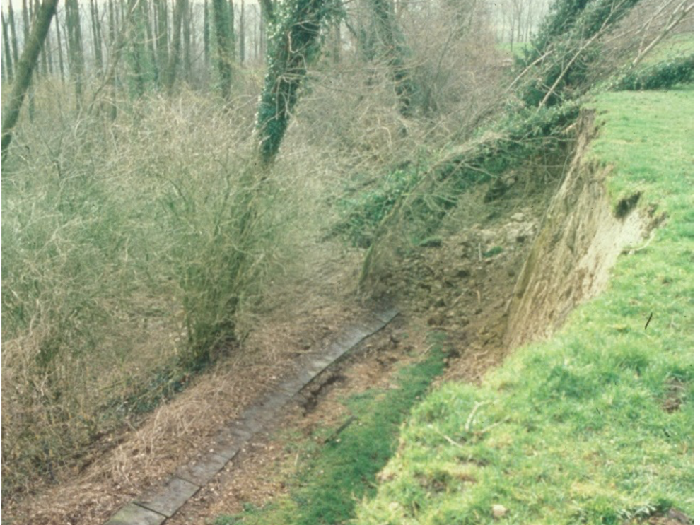
The municipality of Kluisbergen had to act quickly to repair the subsiding adjacent to the Middelloopstraat after the weeks of rain before Christmas 2023. Over a length of more than 70 metres, the hillside slid down, along a steep slope up to three meters deep. The wooden fence was found down there. Note also the orange pipe that exits there, which led rainwater under the road into the slope. Using even more water as a lubricant for that landslide may not have been such a good idea in retrospect.

The E3 Saxo Classic is on the calendar on 22 March and De Ronde nine days later. What is De Ronde without the tandem Kwaremont and Paterberg?
Iron plates have now been drilled in and the cavities next to the road. They are being filled to ensure that the subsidence does not worsen. The concrete is setting. The fences are repaired and the road is stabilized. They open to cyclists already and will reopen to cars on the Thursday before the E3 Saxo Classic.

It was a race against time that kept not only cycling fans in suspense but also the treasurer of the Kluisbergen municipality because this geological hurdle on the way to glory in the E3 and De Ronde is certainly not a cheap one. It costs 300.000 euros! Maybe next time when road are built in this geologically very interesting region, ask a local geologist for advice. It might save a whole lot of money and stress. Happy racing everyone!
Douwe van Hinsbergen was onsite to show you some more Tour of Flanders geology. He explains how to make a Flemish hill.
