
The first Grand Tour of the calendar year brings the peloton to Italy. Even more than in the other two grand tours, we can actually predict the type of stage winner from the geology. The climbers and puncheurs will win in Europe, and the sprinters in Africa. To explain this we bring you the geology of the Giro d’Italia.
Wait! What? Africa?
Yes, Africa.
Or, more precisely: the African Plate. We think in plates in geology, after all.
To understand the geology of Italy a bit, you should quickly forget the geographic map of Italy that you know so well. Just forget that big boot-shaped peninsula with a heel and a toe, and that stuff. That is just a random shape that sea level drew around a rugged topography. No, to understand the geology, it’s better to zoom out and follow the narrow ridges that surround the basins of the Mediterranean Sea. The key to understand the geological history of Italy is ‘Adria’ and that is much bigger than Italy as a nation state.
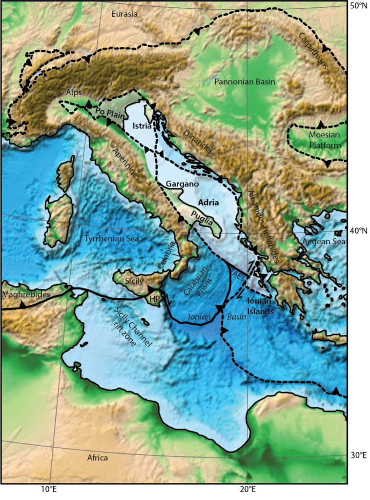
The history of Adria
Adria is a thick piece of old continental crust that is almost entirely lying below sea level in the Adriatic Sea. But the Po Plain, the Italian east coast, the Gargano Peninsula, and the Puglia Peninsula are all part of Adria. These form the only flat regions of Italy: sprinter’s paradise!
Adria is its own continent. It broke off Africa in Triassic to Jurassic time, probably sometime between about 220 and 170 million years ago. Just like Africa once broke off North and South America to open the Atlantic Ocean. This made oceanic crust, which formed at a mid-oceanic ridge, that now underlies the Ionian Basin. But after 170 million years ago, this ridge died, and Adria became part of the African Plate again. It stayed part of the African plate ever since although it’s moving a little bit relative to Africa. When I say move, it’s a millimeter per year or so. When you see a sprinter win a stage in the Giro, it’s a safe bet that he won on the African Plate.
But if you were surprised to learn that Adria is part of the African Plate, then you may be double surprised that Sicily is not just the African Plate. Most of it is actually just Africa! The shallow sea between Sicily and Africa is just a flooded part of the African continent: Sicily is geologically speaking African crust.
Back to Europe
So if the sprinters win in Africa, how come the mountains are ‘Europe’ then?
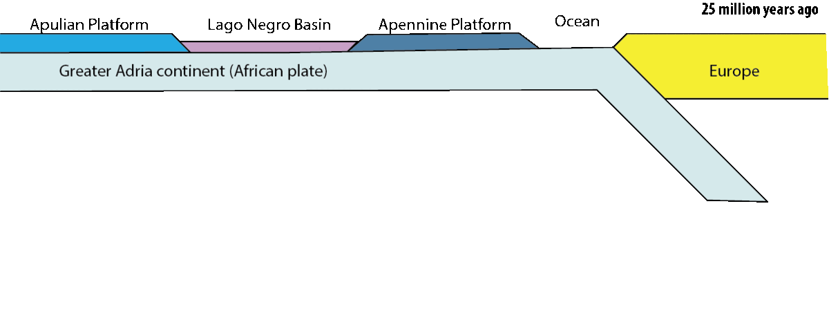
Along most of its northern margin, the African plate has taken brave attempts to dive into the mantle by the process that we call subduction. I’m saying brave attempt, because it has not everywhere been quite successful. You’d think that plates would prefer not to subduct at all and just stay at the surface. However in the Mediterranean region, both Europe and Africa have been battling for more than 170 million years who got to go under. Africa won in the west and east, and Europe won in the center. I’ll get back to that in a minute.
Going under
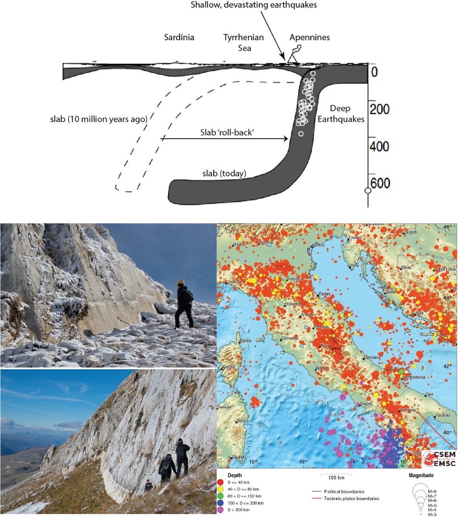
So how does this process of subduction lead to the formation of mountain belts? Tectonic plates are somewhere between 60 and 150 km thick. And when one dives below the other into the mantle, almost all of that plate disappears and sinks away. But sometimes, the top few kilometers of rock, mostly layers of sediments, are offscraped and get piled up. Like a tablecloth you push away, for example. In the 2D animation you can see how this worked for the Apennines.
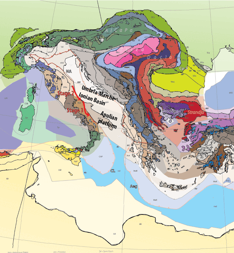
Right now, the Apennines consist of thick rock slices that were thrust on top of each other in the last 15 million years or so. And even though they are only sedimentary rocks, we can tell from their composition what type of crust they were originally on top of. That tells us more about the geological history. Coral reefs form in shallow seas, often on continental edges. Deep in oceans we find fine-grained oozes of limestone mud or chert. The sedimentary rocks of the Apennines tell us that they formed on the edge of Adria, which must have been much bigger before it became ‘Apennines’. And west of Adria was a once an ocean that we call ‘Alpine Tethys Ocean‘.
Greater Adria
The Apennines are not the only offscraped remains of the edges of Adria. In fact, Adria was once huge. So I called it ‘Greater Adria’ a few years back. The deformed top rocks of Adria are also making the mountain belts of the Dolomites in northern Italy, the Dinarides of the Balkan, the Hellenides of Albania and Greece, and the Taurides of Turkey. This goes all the way to the Turkish-Iranian border.
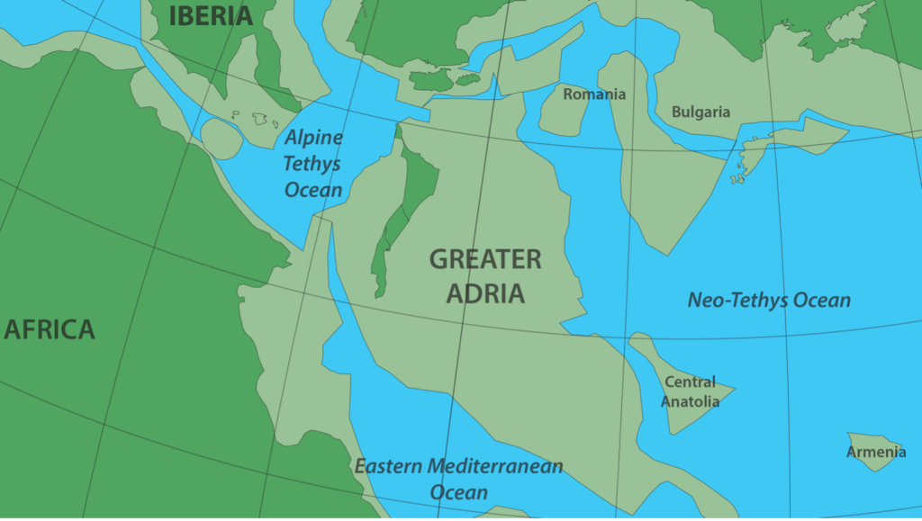
When Greater Adria is restored in its original dimension that it had about 150 million years ago, it was the same size as Greenland! Only, it had no ice caps. In fact, most of it was under shallow sea water. Ideal to make reefs and platforms where limestones formed that we now find everywhere in these mountain belts. ‘Dolomite’ is a special kind of limestone, and have a guess where we find that stuff a lot…
The Alps, Carpathians and Balkanides are not formed from the edges of Greater Adria, but from the edges of Europe. As I said, Africa (and Adria) won the subduction battle in the west, between Italy and Spain, and also in the east, from the Dinarides along Greece to Turkey and Cyprus. But in the middle, Europe went down below Adria, to form the Alps. You can imagine that such a switch leaves a bit of a geological mess, which we find on Corsica, and in the western Alps. Luckily, that’s France, so we’ll deal with that for the Tour de France, shall we? This is after all the geology of the Giro d’Italia
Mountains everywhere
On Sicily, there’s also mountains. I mean, besides the Etna, which is a huge volcano of course (and a very young one, only 600.000 years old). But west of the Etna, there are mountains, which are the deformed northern edge of the African continent, where it hit the Eurasian plate. We know this mountain belt as the Maghrebides. It continues in northern Tunesia, Algeria (Kabylides), and connects westwards with the Rif mountains of Morocco.
And Calabria? Calabria doesn’t belong where it is today. Calabria broke off Sardinia and got stuck in the gap between Africa and Adria. But to understand how that works, I have to explain another process to you that is important in Italy: roll-back.
Roll-back
The textbooks in high school tell you that when two plates are squeezed together, one will be shoved below the other and disappear into the mantle. It’s the process of subduction. But once it went down some tens of kilometers, mineral reactions will start occurring that makes such plates denser and denser. It can happen that the plate becomes so dense, that it starts to sink faster than that the two plates are coming towards each other. And what happens then?
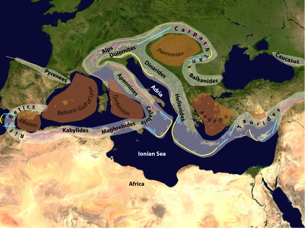
When subducting ‘slabs’ sink faster than that the plates converge, they ‘roll back’. They move through the mantle in the direction of the downgoing plate. That means that the upper plate needs break up and becomes stretched. This process is happening all along the Apennines, and in many other places in the Mediterranean region. It also happened in the Betic-Rif belt in the west, in the Carpathians-Pannonian region of Hungary and Romania, and in the Aegean region of Greece for instance (see map).
It’s still going on
The subducting slab that was pulling Adria down into the Apennine subduction zone has been rolling back for the last 30 million years, and broke up the upper, European plate. That first broke Sardinia and Corsica off the southern French margin of the Provence. As a result, the Gulf de Lion basin opened. Next, Corsica and Sardinia were left behind, and the early Apennines that had started forming against the eastern edge of Corsica and Sardinia, kept moving. This opened the Tyrrhenian Sea basin in the last 10 million years or so. In the south, a fragment of Sardinia – Calabria – came with the Apennines and moved to the southeast. And now it looks like the ‘toe’ of the boot, but it has only been there for a few million years.
You think, this is ancient history but no. This process of roll-back is continuing today: even the Apennines themselves now become stretched as a result. This stretching is accommodated along large faults, where the top block is sliding downwards. We call those ‘normal faults’ and they are the main reason that there are so many devastating earthquakes in Italy.
Explosive Italians
Finally, Italy has the largest collection of active volcanoes of Europe. And when you look at the map it’s clear that those are located in, and west of the Apennines. These volcanoes, including the most famous beasts such as Vesuvius, Stromboli, and Etna, are all somehow related to the process of subduction. Some volcanoes, such as Stromboli, form because water is brought down into the mantle by subduction, below Calabria. This lowers the melting point of the mantle and causes volcanism. This is the type of explosive volcanism that you can find all around the Ring of Fire.
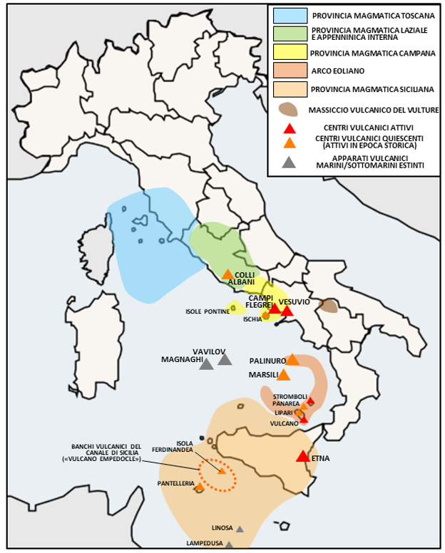
Other volcanoes, such as Vesuvius, form because the Apennine slab has had enough of Adria and is breaking off. Arrivederci. Mantle rocks that move into the gap can melt to produce volcanism. This can be just as explosive, as the inhabitants of Pompeii experienced almost 2,000 years ago.
Finally, the slab of Calabria has an edge below Sicily. Mantle rock that is flowing around that slab may melt causing volcanism just above the edge. This is the cause of Mount Etna.
All this geological violence: from colliding and subducting plates that are both offscraped and roll back, and earthquakes and volcanism makes for some serious topography that makes the territory of the puncheurs and the climbers. It’s the ideal territory for the geo-cyclist! Happy Giro everyone!