Can you imagine a world where Scotland and England are two different beasties? Geologically speaking, that is – we won’t get into any other debates, We promise! So, here’s the scoop: way back when, the Scottish Highlands and England were part of two ancient continents. Scotland was part of Laurentia which was North America and Greenland before the Atlantic ocean split them. England was part of Avalonia, a ribbon-like continent that included Wales, southern Ireland, Belgium, the Netherlands, northern Germany plus the Atlantic coast of Canada and New England in the USA.
Larentia and Avalonia were once, literally, oceans apart: with the vast Iapetus Ocean between them. This ocean subducted below Scotland resulting in large volcanoes in the Highlands. The continents Avalonia and Laurentia collided 420 million years ago, placing Scotland on top of England in the continental marriage that we see today. It wasn’t the best of marriages though, a bit like many of the Gretna Green elopers we guess.
In the Carboniferous, so 340 to 330 million years ago, Scotland and England applied for divorce. Amicably, of course, continents usually take their time unlike Henry VIII. During the time a deep rift opened up between Laurentia and Avalonia called the Midland Valley. Scotland and England decided that it wasn’t the time for a continental break-up. They decided to keep it together and give each other some space: they kept the Midland Valley. This valley has witnessed lakes, rivers, shallow seas and volcanoes. The Glasgow World Championships course goes right through it.

The Midland Valley of Scotland is a geological mosaic of tough igneous rocks, formed during the Carboniferous volcanic activity, and the much softer sedimentary rocks like sandstone, limestone, and coal. This unique combination of rocks is the result of the formation of a continental rift valley, like the Eastern African rift today, but in a humid equatorial environment similar to the western Africa or the Amazonia. It is common to find the remnants of a Carboniferous basaltic volcanos formed into a shallow lake, and gradually built vast edifices surrounded and covered by lush tropical forests.
Within the sediments and lava flows, geologists have discovered fossilized burnt plant remains, and coal seams a glimpse of such ancient ecosystems preserved in time. The best examples of the volcanisme are found in The Campsie Fells, new Glasgow, where up to 33 volcanic eruptions piled up during the Carboniferous (some 345-330 million years old). The lavas, now crystalized as a rock known as basalt, looked like columns due to the effect of contraction during cooling. These hills are the home of the legendary Phillippa York, who won the King of the Mountains in the Tour de France in 1984.
Other remnants of the Carboniferous volcanism is the Midland Valley Sill, formed a 330 million years ago. The riders will climb it at the end of the time trial at the Stirling Castle hill. Geologists call sills to the rocks that result from the injection of molten magma between layers of sedimentary rocks, which later cools down. While the final appearance might ressemble to sedimentary layers, geologists can tell that the sill intruded the sediments because the rocks surrounding the sill appear “backed” due to the intrusion.

But the unique combination of hard and soft rocks is not only interesting because of what its tells us about the Carboniferous story of Great Britain. Today’s landscape is controlled by these rocks. Most of the routes of the world championships take the riders through Scotland’s youngest landscapes, shaped by glaciers that made their grand entrance about two million years ago during the ice ages.
These glaciers marching in from the North Sea crafted the crag and tails landspes that we see. The rocks that are now hills such as the ones where the iconic Stirling Castle and the Wallace Monument now stand on, fiercely resisted the erosion of the icy sculptors forming the “Crags” (rocky hill in Scots). And those flatlands? Well, they were the soft rocks that represented the runway for the glaciers, where they could flow effortlessly forming the “Tails”.
About 16,000 years ago, the ice started to melt, and Scotland finally got its much-needed break from the cold embrace. During the melting of the glaciers, sea levels rose as rapid as a the career of Tadej Pogacar – up to two centimeters per year! From being about 120 meters below present-day sea level 16,000 years ago, the sea levels eventually rose to where they are today, 6,000 years ago. Places like the Forth Valley, running parallel to most of the time trial, found itself flooded by the rising sea, creating a massive fjord. Along with the sands and muds left behind by the sea, whale bones have been discovered along the route, some of them even have flint arrows still embedded in them.
Once that massive ice cap said goodbye to the top of Scotland, it set off a slow-motion rebound process. Picture unloading a boat, it rises up as the weight is lifted. Similar story with the ice weight, as it was removed from the Earth’s surface, the land began to rise in what we call isostatic rebound. But here’s the catch: since the lithosphere and mantle of the Earth are solid, not liquid, this process takes millennia to unfold. Scotland has been on the rise about 1-2 mm per year since those glaciers melted. Thanks to this uplifting story, the sea gradually retreated, turning the once-flooded fjord into a vast bogland. Although most of the 8-meter-thick peat layer has been removed since the 18th century, one large fragment remains, the Flanders Moss. Riders will be, for sure, quicker than the isostatic rebound and the races will light the fire, but we promise the volcanoes won’t.
Road Geo-landmarks
ARTHUR’S SEAT: This striking landmark is the remains of the vent system of a Carboniferous basaltic volcano. The story started when a volcano was emplaced into a shallow lake, and over time, it built up a magnificent edifice, covered with thick tropical forests. Between lava flows and sandy layers we find fossilized burnt plant remains today, offering us a glimpse of ancient landscapes frozen in time. Just to the north of Arthur’s Seat, we find Whinny Hill, a series of lava flows that originated from the same volcanic source as Arthur’s Seat. The lava flows find themselves sandwiched between carboniferous sediments of the lacustrine and fluvial kind.

FIRTH OF FORTH: Firth of Forth is a estuary (Firth is stuary in Scottish) famous by their awe-inspiring Bridges. In the central belt of Scotland, we encounter a geological mosaic of tough igneous rocks, formed during volcanic activity, and the easier to erode sandstone, limestone, and coal. This combination created the coastline of the Firth of Forth and its perfect narrowing point at Queensferry where the world-famous bridges stand. This narrow point occurs where the hardest rocks crop out: the sills from the large Midland Valley sill complex. The igneous rock here, is as quartz dolerite, originated 330 million years ago when magma intruded into layered sedimentary layers, and is particularly hard because of its higher content in quartz, a very resistant mineral to erosion.

CURLOSS MINING: The rich history of coal mining in Fife, Lothians, and Bo’ness dates back to the 13th century. In Culross, Sir George Bruce engineered the Moat pit in the 1660s, a marvel that consisted of a 40ft shaft allowing access to coal seams deep underground, extending under the Forth.
BEARSDEN: We have talked about volcanoes and sedimentary layers that are very rich in plant fossils. But Bearsden is the home to the extraordinary discovery: a 330 million year old shark. The shark, found in the 1980s by Scottish palaeontologist Stan Wood, is so exceptionally preserved that the shark’s last meal is visible inside its stomach, along with blood vessels and remnants of its muscles. This specimen, named Akmonistion zangerli, has affectionately earned the nickname of ‘Bearsden Shark’ and now resides in Glasgow University’s Hunterian Museum.
GLASGOW: Both men’s and women’s races end in an urban route in Glasgow. Glasgow’s heart hides a geological tale beneath its streets. Although the concrete dominates, scattered exposures, drillholes, and mining revelaed Carboniferous sedimentary rocks deposited by ancient rivers, deltas, and lagoons. The city’s landscape, however, is again the results of glaciers that carved away the sedimentary layers and formed “drumlins” (from Irish, slongated hill) hills of soft sediment of a few hundred meters in length that have been streamlined by the glacier flow. The University of Glasgow graces a drumlin’s crest in the west.

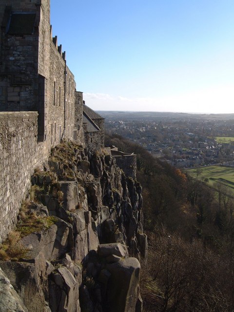
STIRLING CASTLE: The time trial ends on Stirling Castle hill, a prominent steep-sided ridge of rock sculpted by the erosion of the glaciers. This rock, called dolerite (which is the same composition as basalt, but slightly coarser grained), is part of the Midland Valley Sill, that formed 330 million years ago. Geologists call igneous rocks a sill if they are the product of injection of molten magma between sedimentary layers of rocks, and then later cools down. Although the final product looks like a sedimentary succession of rocks, geologists know that the sill intruded the sediments because the sediments that sandwich the sill look backed!
BALLOCH TO BALFRON: The women’s race starts in a section that looks relatively low lying, but don’t let that fool you! This is a landscape packed with the remnants of those melting glaciers. Get ready for an undulating terrain, with short and steep hills, drumlins, and glacial moraines left behind by the last glacier that cruised down Loch Lomond approximately 12,000 years ago. The flatter sections are nothing less than long valley floors and the former beds of ice dammed lakes. As the riders climb up into the Campsie Fells, around and above Fintry, the riders will find the steeper sections along the route: ice carving at its finest. These hills show steep cliffs and a breathtaking glacial cirque (a rounded and half-openhead of a valley in a mountain formed by glacial erosion), the Corrie of Balglass (corrie is cirque in Scots).
(with thanks to Angus Miller (@Geowalks), Davie Brown (@daviebrown1978), Andy Bell (@andyfbell), Katie Strang (@scottishgeology), and Eileen Tisdall (@eileentisdall))