Stage 16 is a short time trial but the geological history of the region is all but short. Oceans opened and closed. The Alps were lifted in a curved shape. Today, you will learn why.
Today the riders will be speeding over sedimentary rocks deposited during the middle Jurassic period. This was the period between ~175 and 160 million years ago. We race in a narrow sea called Alpine Tethys. This sea formed when the supercontinent Pangea, ultimately assembled in the Permian, ~300 million years ago, started to break up in the early Jurassic (~180 million years ago).
Pangea was split into two major landmasses. There was Laurasia to the north (North America, Europe, and west Asia) and Gondwana to the south (South America, Africa, Australia, and India). The approximately East to West trending crustal fracture separating the two blocks was soon invaded by seawater of the newly formed Alpine Tethys. Ongoing separation between Laurasia and Gondwana led to the expansion of the Alpine Tethys. It resulted in the rapid drowning of once-emerged lands at its margins. It also caused deposition of new sediments above them including the Jurassic rocks we race on.
A short history of the baby ocean
Formation of oceans and mountains is controlled by the motion of tectonic plates. Plates never stop and can rapidly change their motion. They sometimes even invert it. Motion comes after any new process begins elsewhere around the globe (i.e., a new ocean forming or being consumed somewhere). You can call this the “plate tectonics butterfly effect”. This was exactly the case of the Laurasia and Gondwana blocks. They were happily moving apart during the early-middle Jurassic. Then they suddenly started to move towards each other in the late Jurassic, around 100 million years ago. This rather unpredictable event was in fact caused by the opening of the Atlantic Ocean further to the west. That split Gondwana into two (South America and Africa) and pushed Africa to the north towards Laurasia. Squeezed in between, our ‘baby ocean’, the Alpine Tethys, was set to a rapid and dramatic end!

A stack of rocks
The convergence between Africa and Laurasia acted as a wrench on the still narrow Alpine Tethys Ocean. It stopped its expansion. Following continuous convergence, the Alpine Tethys inevitably began to shrink, accommodated by a process called subduction. Its history became a short one. When the last piece of this ocean was consumed in the late Cretaceous (~80-70 Ma), the two landmasses of Africa and Laurasia (now Europe) eventually reunited after some 100 million years of separation (quite a long divorce!). While doing so they smashed everything in between. All the sediments deposited within the Alpine Tethys, the volcanic rocks that floored this ocean, and even deeper rocks from both the European and African margins were faulted, folded, and uplifted. They formed a stack of tectonic sheets that over the course of several millions of years reached 5 km elevation. This stack of rocks is today known as the Alps!
Show me your curves
When you think of a mountain belt, you probably think of some laterally straight relief. However, if you observe today’s shape of the Alps you will easily notice that it is not at all straight. In the west it forms a horseshoe curvature known as the Western Alpine Arc.

Today’s stage is located just at the northernmost tip of this arc. It’s where the E-W trend of the Alps starts to bend southward.But how can such a curved mountain form? Geologists think that the western Alps formed initially as a curved mountain. Compare it to the rounded creases created when you push a table cloth with a fist. The soft sediments over the European margin were faulted and folded by a small ‘fist’ pushing into them during Africa-Europe collision. This ‘fist’ was Adria, which at that time formed a small, rigid block sticking in front of the African plate (see Fig. 2).

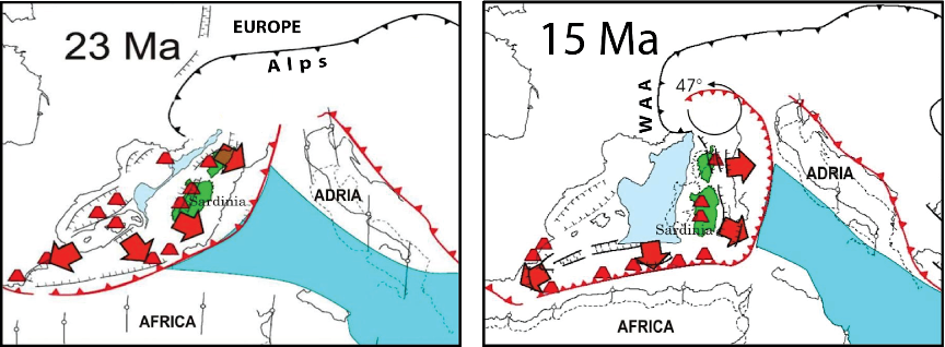
Double trouble
Mountains that form and rise with a curved shape are called primary arcs. Another type of curved mountains are those forming originally long and straight, but then are bent into an arc by later geological events. These are called oroclines. Geologists have found evidence that the initial curvature of the western Alps was increased by another 45-50° during the Oligo-Miocene periods. This was between ~25 and 15 million years ago so several million years after the first uplift of the belt. This subsequent event was related to the separation of Corsica and Sardinia from Europe. This acted as a wrench on the western Alps, bending its southwesternmost tip. Due to its complex geological history, the Western Alps are therefore both a primary arc and an orocline!