
The riders of the Tour de France can sometimes be a force of nature when they climb the biggest mountains, race against the clock or defy dazzling speeds in bunch sprints. Today’s stage gives us more force of nature as we look into the gigantic forces that created mountain ranges.
We are in the Auvergne-Rhône-Alpes, a region of eastern France. Today’s 152-kilometer long stage between Annemasse and Morzine offers two big climbs. The Col de la Ramaz and Col de Joux Plane are both over 1600 meters. This stage enters the westernmost portion of the French Alps. These formed due to collision between the African tectonic plate in the south with the Eurasian tectonic plate in the north. This collision began ~35 million years ago and is ongoing today. Yes, it’s still on. Much of the iconic scenery in this region of France, Switzerland, Italy, and Austria is a result of this continental collision. It led to thickening and deformation of the Earth’s crust.
Big rock
Soon after heading east from Annemasse, the riders will enter the Geopark Du Chablais. It’s a UNESCO Global Geopark, like Zumaia of stage 3. It exposes rocks recording over 250 million years of geological activity. This includes formation and uplift of the Alps and their later denudation by glaciers that have carved out deep valleys.

Situated just northwest of Bons-en-Chablais is a popular tourist attraction locally known as “Pierre à Martin”, or Martin’s Boulder. The boulder itself is a metamorphic rock called gneiss. It bears little resemblance to the local equivalents. In fact, geologists suggest that the boulder was transported from Valais – home of the Matterhorn – approximately 100 km away.
How can this massive boulder have travelled so far? Rocks such as this are common in regions that have experienced glaciations in the recent geological past. Ice is a powerful natural phenomenon that can carry heavy rocks long distances during a glacier’s migration. When the glacier melts, it drops its geological load onto the landscape below. These dropped rocks, such as Pierre à Martin, are called erratic blocks. They are useful for scientists looking to recreate past climates. For example, the careful study of where erratics originally came from can reveal how glaciers moved during previous ice ages.
A devil’s force of nature
At around the halfway point of this stage, on the other side Mont Billat, is the commune of La Vernaz. It is home to the Gorges du Pont du Diable, located on the River Dranse. The gorges are testament to the erosive power and force of nature, which can work slowly and consistently over millions of years. The foothills of the Alps in the Haute-Savoie region are made of limestone, which is a relatively soft rock that is easily weathered.
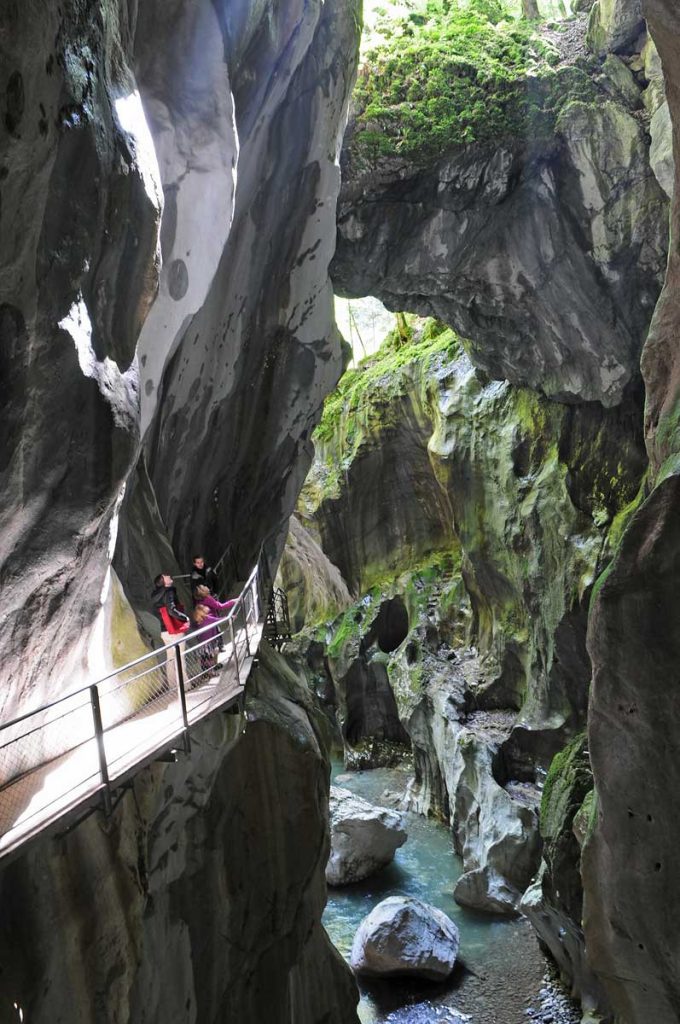
The Gorges du Pont du Diable expose near-vertical, 50 metre-high walls. They were carved out by subglacial rivers that passed beneath Alpine glaciers during the last ice age. Now, the gorges host the River Dranse, which flows northwards into Lac Léman (Lake Geneva). A major attraction in the region is an isolated block of rock that is wedged between the gorge’s walls. It is situated about 30 meters above the river below. Likely a glacial erratic that was dropped into this position while the river below continued to erode and deepen the gorge, this forms an imposing arch. It is locally known as Le Pont du Diable, or “The Devil’s Bridge”. It can be used to cross from one side to the other.
Orogeny, or mountain building
The finish line for Stage 14 is in Morzine. Before the riders celebrate, they have to traverse Col de la Ramaz and Col de Joux Plane, both of which breach elevations of 1600 m. These peaks are clear evidence of the immense geological forces involved with creating mountain ranges, such as the Alps and the Himalaya. The Earth’s rigid outer shell – the lithosphere – is broken up into several plates of varying sizes. These move independently across its surface. Where two plates converge, extreme compressive stresses act to uplift and deform sedimentary material that is caught up in the collision zone, forming folds. These rocks are buried and heated, and so become metamorphosed.

Morzine itself is famous for its slate. It is a low-grade metamorphic equivalent of a mudstone. It can be found in cliffs that overhang the Valley de Sous le Saix (Slate Valley). Slate was quarried from this region and used as a local building stone for over a century between 1856 and 1963. The metamorphic rocks that make up the Col de la Ramaz and Col de Joux Plane are higher-temperature schists and gneisses, but likely still formed from similar humble beginnings as ocean-floor sediments that became unlucky participants in formation of the Alpine orogenic belt.
Douwe uses some cheese in this video to explain the orogenic processes in the Alps.
