Stage 20 and the general classification might or might not be complicated by now but the geology of today’s region is complicated. And so is our blog but after 20 days of Tour de France geology, you are basically experts. So here is a deep dive!
We are in the Vosges mountains and it’s home of the Ballons. We have Ballon d’Alsace (1247 m), Grand Ballon (1424 m), the highest point of the Vosges mountains, the Petit Ballon (1272 m), which riders will climb later in the stage, the Ballon de Servances (1216 m) and the Ballon Saint-Antoine (1128 m). The origin of this particular toponym, ‘ballon’, remains to date a bit of a mystery. Maybe its origin can be found in the geology of these mountain tops. ‘Ballon’ may indeed refer to the ‘rounded shape’ of the mountain tops, referring to ‘bulla’, the Latin for ‘spherical object’.

Huge granitic bodies, which geologists call ‘batholiths’, tend to weather into rounded mountains tops. You may all know the iconic Half Dome in the Yosemite National Park in California.
And indeed, the southern Vosges mountains expose such huge granitic batholiths. They are all remnants of 350 to 330 million years old magmatic activity during the final stages of the Variscan mountain building, which finalizes the formation of Wegener’s supercontinent Pangaea.
Vosges, a geologist’s brain teaser
The British geologists John F. Dewey (1937-), one of the founding fathers of plate tectonics, once wrote that “plate tectonics is, inherently, a simple beautiful concept, but its smaller-scale results are bewilderingly complicated”(Oreskes, N. 2001). That is exactly what geologists are experiencing attempting to decipher the tectonic history of the Vosges mountains. The Vosges are really a geologist’s brain teaser. Aka: it’s complicated.
When you hear about plate tectonics, you probably remember what you have learned in school. The Earth’s surface is composed of a limited number of large, rigid, lithospheric plates – some of which bear continents – that move with respect to each other, reacting to convective flow in the Earth’s mantle. And along the boundaries between these ‘grinding’ lithospheric plates earthquakes and volcanoes are common.
Continents break up and oceans form. These oceans grow along divergent plate boundaries, where new oceanic crust is created. Continents drift apart. When a subduction zone forms along a continental margin, one plate starts to plunge underneath another plate. This changes the continental margin into an active, converging plate boundary.

Continents start to converge and the intervening ocean gradually closes. Eventually continents collide and huge mountain chains rise. We geologists call this evolution from continents that break up to continents that collide the ‘Wilson cycle’. It is named after the Canadian geophysicist John Tuzo Wilson (1908-1993). He was another founding father of plate tectonics.
Terrain and terrane
This ‘simple’ model of plate tectonics is primarily developed from an ‘oceanic’ perspective, based on oceanic research. That’s the reason why John F. Dewey called it a ‘simple beautiful concept’. Continental geologists, though, don’t really recognize this simplicity in the architecture of the mountain chains they study. Not in active mountain chains such as the Himalayas and not in the vestiges of old mountain chains, such as the Pan-European, Variscan mountain chain, which core we see exposed in the Vosges. What continental geologists see in these mountain chains is a puzzle of continental fragments and oceanic slivers. Geologists call these fragments – of all possible sizes – ‘terranes’ not to be confused with ‘terrain’, which just refers to the physical geography of an area. Words do matter!

A classic example of such a ‘terrane assemblage’ is the North American Cordillera. You can find it along the Pacific coast of the US and Canada. Although this region has been a continental margin for hundreds of million years, the Cordillera mountain range reflects a nearly continuous orogenic activity. This continuous mountain building does not result from a collision of two continents. No, it is caused by a sequence of accretions of continental and oceanic fragments. Sometimes, these fragments are even seemingly unrelated to the adjacent continent, suggesting that they are coming from far away. That’s why we call these fragments ‘exotic terranes’.
These orogenic puzzles of accreted terranes indicates a high degree of tectonic mobility. That is difficult to reconcile with the simple model of mantle convection driving plate movements. Accretion tectonics indeed implies a very mobile image of plate tectonics, with ‘jumping’ or ‘reversing’ subduction zones, short-term ocean formation, etc. They are all geodynamic processes that are incompatible with the sluggish convective flow in the mantle. Plate tectonics indeed tells a ‘bewilderingly complicated’ story of its own!
Back to Europe: still complicated
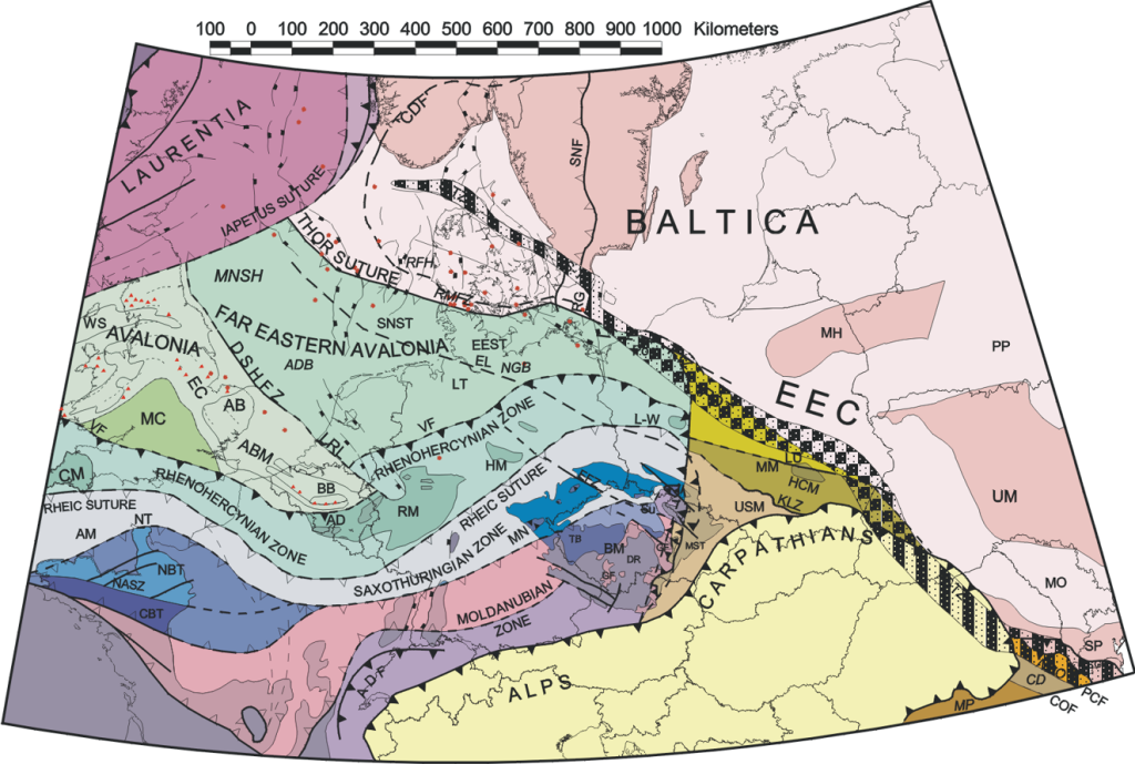
Also the European subsurface, south of the Precambrian Baltic cratonic shield, consists of an amalgamation of terranes. And all these tectonostratigraphical domains were once continental fragments of the ‘old’ (Palaeozoic) southern supercontinent Gondwana, or its (Meso-/Cenozoic) successor continents Africa and South-America. That’s why we call all these fragments ‘peri-Gondwanan terranes’. These terranes listen to names, such as Avalonia, Armorica, Iberia, Apulia. If you need inspiration for a new age rock band? Once these terranes are incorporated into the Variscan orogenic system, they are known as the as e.g. the Rhenohercynian, Saxothuringian, or Moldanubian.

Within this European terrane puzzle, the Vosges mountains occupy a particular position. We recognize in the Vosges mountains the vestiges of at least four tectonostratigraphical domains. From North to South it’s Avalonian, Rhenohercynian crust, Saxothuringian crust, Moldanubian crust, and eventually even Gondwanan crust all the way in the South.
All these continental slivers were once part of the Gondwanan continent. They drifted away early in the Palaeozoic, more than 400 million years ago. These microcontinents drifted to the North in the Rheic Ocean, in front of the northwards drifting Gondwanan supercontinent. The Rheic Ocean started to close and the Gondwanan supercontinent was converging to Baltica and Laurentia, already merged with Avalonia to form the northern ‘Old Red’ supercontinent. The peri-Gondwanan continental slivers were accreted one by one. They squeezed together in the Pan-European, Variscan mountain chain, expressing the ultimate formation of Wegener’s supercontinent Pangaea.

Tour de Gondwana
In the final stages of the mountain building in the Vosges, some 320 million years ago, massive magmatic activity was related to upper-crustal unroofing of the Variscan orogeny. This eventually leads to the final complex architecture of the Vosges. That makes it a real brain teaser for any continental geologist. Climbing the Vosges mountains, crossing different sutures between the peri-Gondwanan terranes, makes today’s stage a bit the ‘Tour de Gondwana.”

